Kadi Fm
Type Locality and Naming
SUBSURFACE: Well South Kadi – 4, (depth interval 1345-1816 m). It is of 471 m thickness. [Original Publication: Chandra, P.K. and Chowdhary, L.R. (1969) Stratigraphy of the Cambay Basin, ONGC Bulletin, Vol 6 (2), pp: 202-203.]. Reference well: Pandey et al. (1993) have designated four reference sections, including Sobhasan-24 (depth interval 1191 – 2062 m), its thickness is of 871 m.
Synonyms: The name Kadi Formation was proposed by Chandra and Chowdhary (1969) for a thick clastic wedge encountered in subsurface in well Kadi-4 (later named as South Kadi-4) drilled in Kadi in the northern part of Cambay Basin. The formation has earlier been referred to as ‘Mandhali Formation’ and ‘Mehsana Formation’ by Bhandari and Mathur (1968). However, later Bhandari and Chowdhary (1975) redesignated these two formations as Mandhali and Mehsana members of the Kadi Formation on the basis of their similarities in distribution and environment of deposition (Source: Pandey and Dave, 1998).
Lithology and Thickness
Clayey sandstone and coal. In type section. it is characterized by alternations of sandstone, siltstone and coal with layers of shale. Shale is dark grey, sideritic and carbonaceous. Coal is black moderately hard, sub-vitreous to dull luster. Thickness of 871 m in UA and WA-1 wells. In the type well South Kadi-4 the thickness is 471 m.
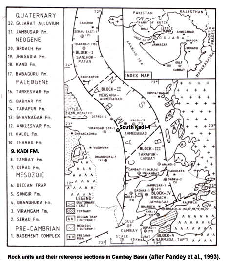
[Figure 1: Rock units and their reference sections in Cambay Basin (after Pandey et al., 1993)]
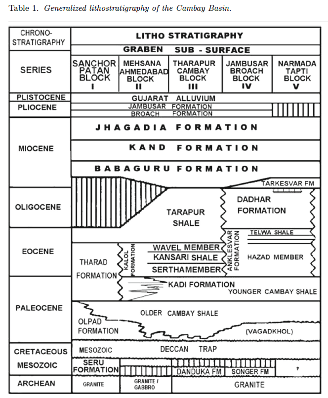
[Figure 2: Generalized stratigraphy of the Cambay Basin. (from Jaiswal and Bhattacharya, 2018, J.EarthSyst.Sci., 127:65)]
Relationships and Distribution
Lower contact
Conformable with younger Cambay Fm shale.
Upper contact
Regional extent
Kadi formation is present from Unawa in the North to Galodra, North Kadi, North Kalol, Sobhasan, Allora, Warosan, Linch, Jotana, Mehsana, Akhaj, Kherwa, Mewad, Langhraj, North Dholasan, South Dholasan, and Saladi areas, in Mehsana sub-block.
GeoJSON
Fossils
The formation is mostly unfossiliferous. However, a few ostracods represented by Alocopocythere abstracta, Buntonia boldi, broken shell fragments, gastropods shells, dinoflagellates and pollen species were recorded from the Nandasan well – D. Important palynofossils: Proxaperites hammenii, Psilodiporites hammenii, Tricolpites densioranatus, Marginipollis concinnus and Spinizonocolpites echinatus etc.
Age
Depositional setting
Additional Information

